Real time lightning map and rainfall radar as thunderstorms hit the UK
1 August 2024, 12:35


The latest lightning map and rain radar as The Met Office issue Yellow weather warning for thunderstorms.
Listen to this article
Loading audio...
Thunder and lightning are expected to hit the UK today, with many of us wondering if we can track these strikes by map.
After a four-day heatwave, the 1st of August is set to see a mix of sunshine and showers as we kick the month off with some thunderous weather. The Met Office have issued a Yellow weather warning for thunderstorms until 23:59pm this evening, and have even warned of a danger to life due to deep floodwater.
After some scorching heat in Europe, these dramatic conditions are heading our way, leading many of us to wonder where and when these lightning strikes and heavy rainfall will arrive.
- Listen on Global Player, the official Heart App: The Sports Agents with Gabby Logan and Mark Chapman
When will the thunder and lightning start? Here is the latest lightning tracker and rainfall radar.

Lightning Map
The thunderstorm is set to hit the UK this afternoon, with scattered heavy showers which could lead to flooding.
The Met Office have stated there is some "uncertainty" regarding today's weather, commenting: "Whilst there is some uncertainty, thunderstorms may affect southeast England during the early hours of Thursday, perhaps also extending into parts of East Anglia.
"Where these occur, rain accumulations of 25-40 mm are possible in 1 hour, with a small risk of over 60mm in 2-3 hours, and accompanied by frequent lightning at times.
"Elsewhere, an area of showery rain is likely to develop and move northeastwards across parts of Wales, the Midlands and northern England."
- Read more: Seven tips to keep cool at night without a fan during the heatwave
- Read more: The two-second fan trick that could help you sleep during the heatwave

They also warn that this temperamental weather could lead to power cuts, difficult driving conditions, road closures and damage to some buildings from floodwater, lightning strikes, hail or strong winds.
You can follow along to the latest lightning action by visiting Netweather.
Watch the Met Office forecast for Thursday the 1st of August here:
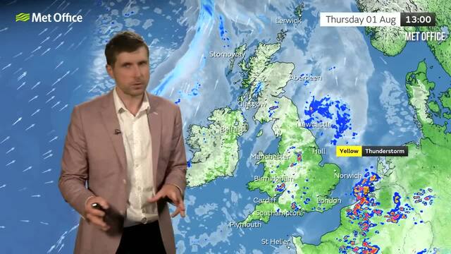
Met Office predicts thunderstorms as yellow warning is issued for the UK with heat and humidity remaining
Rainfall radar
There are flood alerts in place in the following locations on Thursday the 1st of August:
- East Midlands
- East of England
- London & South East England
- North East England
- North West England
- South West England
- Wales
- West Midlands
- Yorkshire & Humber
A Met Office spokesperson said: "Some areas could receive rain accumulations of 25-50 mm over the course of a few hours. Scattered heavy showers and thunderstorms are then expected to develop through Thursday afternoon and evening across parts of central, southern and eastern England, and perhaps also south Wales.
"These have the potential to produce 50 mm or more in one to two hours, along with gusty winds, large hail, and the risk of surface water flooding."
- Read more: Is it too hot to walk your dog and can you give your pooch ice cubes to cool them down?
- Read more: What should I do if I see a dog locked in a hot car?
- Read more: The two-second fan trick that could help you sleep during the heatwave


