On Air Now
Early Breakfast with Lindsey Russell 4am - 6:30am
4 September 2020, 16:36

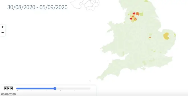
A new map from Imperial College, London, has predicted potential new Coronavirus hotspots in the UK.
An interactive map has shown potential coronavirus hotspots that could emerge in the next three weeks.
The map, which is from Imperial College, London, suggests that Breckland in Norfolk may be among the high risk areas in the next fortnight.
Read more: Nadia Sawalha believes 'outdated' GCSEs should be 'scrapped' as they make kids depressed
As reported by The Sun, The team define a 'hotspot' as an area where there are already more than 50 cases of Covid-19 per 100,000.
Find out more information on the map on the Imperial College website

Other hotspots are areas in the north of England, including including Bolton, Greater Manchester, Rossendale, Lancashire, and Leeds, West Yorkshire.
Read more: Diarrhoea, stomach aches and sickness could be sign of COVID-19 in children, study finds

Denise Welch unleashes enraged rant over coronavirus on This Morning
South Tyneside in Tyne and Wear and Pendle in Lancashire, which have already been flagged as hotspots, also show a high probability of remaining so in the next few weeks.
The team behind the map used data on daily reported cases and weekly reported deaths, as well as mathematical modelling, to report how likely it is that each area will become a hotspot.

Speaking about the map, Professor Axel Gandy, from the Department of Mathematics at Imperial, said: "The model allows us to project where local hotspots of Covid-19 are likely to develop in England and Wales based on the trends that we are seeing in those areas.
"Covid-19 is, unfortunately, very much still with us, but we hope this will be a useful tool for local and national governments trying to bring hotspots under control."
NOW READ:
Couples will be able to marry in their own homes and over Zoom under new plans